Showing posts with label urban design. Show all posts

Tuesday, March 24, 2015

How I Visualize Change

urban acupuncture
I spent my break in California, a place full of environmentalists and new ideas. Not all of them are good ideas, but they are ideas nonetheless.

It was interesting to see some of the ideas that were all over the place, as I visited San Francisco, Santa Cruz, San Jose, and Monterey. In a few areas I saw organically grown sandwich shops that were so expensive I was surprised anyone frequented them. Other areas had raised speed bump looking curbs.

I decided to search for cool urban spaces, and here is what I found:


The videos were interested and exciting to see what is possible, whether practical or not.

Wednesday, March 4, 2015

Lynch Element Photo Examples: Ballpark Area (SLC)

Lynchs 5 Elements of Urban Design
In our Green Communities class we have been asked to evaluate specific and generic communities. I am currently taking a class on oral, verbal, and visual communication in urban planning as well. Our assignment today had us take pictures of the parts that make up our communities.

Kevin Lynch who studied under Frank Lloyd Wright (one of the most noted architects of all time) at Yale University came up with the idea of elements of a community or city. He called this the mental mapping of the community's citizens. The five elements of any community can be broken down as follows:
  1. Paths: The streets, sidewalks, trails, and other channels in which people travel. Lynch noted that paths were often the predominant elements in people’s image with the other elements being arranged and related along paths.
  2. Edges: May be barriers, more or less penetrable, which close one region off from another, or they may be seams, lines along which two regions are related and joined together.
  3. Districts: Areas characterized by common characteristics, these are the medium to large areas, which observers mentally enter ‘inside of’ and/or have some common identifying character. Distinctive physical characteristics might include ‘thematic continuities’, such as texture, space, form, detail, symbol and building.
  4. Nodes: The strategic spots in a city into which an observer can enter, and which are the intensive foci and from which the person is travelling.
  5. Landmarks: Landmark’s key physical characteristics was singularity some aspect that is unique or memorable in the context. Some landmarks – towers, spires, hills are distant and are typically seen from many angles and from distance, over the top of smaller elements. Other landmarks – sculptures, signs and trees are primarily local being visible only in restricted localities and from certain approaches.

For our assignment today we were asked to take pictures of our assigned community and describe them. Below I have the images I took and the reason why I took them. I am not a professional photographer, but I still think the images of the Ballpark community are quite interesting:

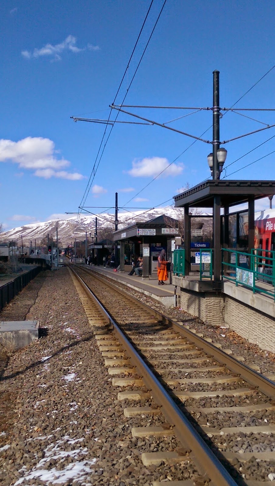
TRAX Station
Path Image: is of the TRAX line running past the Ballpark stop. There are a couple cool elements here: I placed the person in orange just right of center as he creates a main focal point. The TRAX line lead to a point just left of center to help balance the person in orange. The image is heavy on the right side, but is balanced because of the mountain in the back creating a line across the mid section of the image helping create a balance of the heavier right side. The contrast between the bright blue sky and the darker brown ground also creates interest.

Lynch's Urban Design Edge
Edge Image: is of I-15 and the rail line running beneath. 900 South crosses the rail line, and goes under the I-15 bridge. I-15 is an edge of it's own, but the rail line helps to enforce that edge. In addition to the rail line the shadow cast from I-15 also helps define the edge. (I had to wait around a while to get the picture with a train in it so the guard posts would be down as well.) Other interesting things with this photo...in the top right corner you see the bright red sign, that is there on purpose. The shadow line seems to cut the image in 1/2 leading up to that sign. Rail lines have started to make a resurgence, and Union Pacific is one of the biggest, the sign's message makes it a little comical, and again balances the image as most of the weight literally and figuratively is on the left.

Lynch's Urban Design District
District Image: I chose this image to represent the neighborhood district in the Ballpark area. Not only is this image highly typical of suburban neighborhoods, it was highly typical of the neighborhood district of this area. Again you will see the image cut in half with the sidewalk running from the bottom right corner towards the top left. The dark trees fade to the lighter sky and the snow towards the center of the image helps create additional focal points. In usual fashion this image is broken into thirds with the first third being the berm on the left, the center third being the sidewalk and the third section being the grass and houses.

Ballpark
Landmark Image: is of Smith's Ballpark, Home of the Bees. The Smith's Ballpark sign is the center focal point with the large entry way pillars again breaking up the image in very distinct thirds. Your eyes are first drawn to the sign then the pillars, then up toward the sky as the pillars act like giant arrows. The colors draw attention, and although simple the picture has a lot of character.

The next time you walk around your community, see if you can identify it's paths, edges, districts, nodes, and landmarks. Some places might fall into multiple categories, but it will be a fun experiment for you to try.

Wednesday, December 23, 2009

Urban design

Urban design concerns the arrangement, appearance and functionality of towns and cities, and in particular the shaping and uses of safe public space. It has traditionally been regarded as a disciplinary subset of urban planning, landscape architecture, or architecture and in more recent times has been linked to emergent disciplines such as landscape urbanism. However, with its increasing prominence in the activities of these disciplines, it is better conceptualized as a design practice that operates at the intersection of all three, and requires a good understanding of a range of others besides, such as urban economics, political economy and social theory.
Urban design theory deals primarily with the design and management of public space (i.e. the 'public environment', 'public realm' or 'public domain'), and the way public places are experienced and used. Public space includes the totality of spaces used freely on a day-to-day basis by the general public, such as streets, plazas, parks and public infrastructure. Some aspects of privately owned spaces, such as building facades or domestic gardens, also contribute to public space and are therefore also considered by Urban design theory. Important writers on, and advocates for, urban design theory include Christopher Alexander, Michael E. Arth, Edmund Bacon, Peter Calthorpe, Gordon Cullen, Andres Duany, Jane Jacobs, Jan Gehl, Kevin Lynch, Roger Montgomery, Aldo Rossi, Colin Rowe, Robert Venturi, William H. Whyte, Bill Hillier, and Elizabeth Plater-Zyberk.
While the two fields are closely related, 'urban design' differs from 'urban planning' in its focus on physical improvement of the public environment, whereas the latter tends, in practice, to focus on the management of private development through planning schemes and other statutory development controls.
Public spaces are frequently subject to overlapping management responsibilities of multiple public agencies or authorities and the interests of nearby property owners, as well as the requirements of multiple and sometimes competing users. The design, construction and management of public spaces therefore typically demands consultation and negotiation across a variety of spheres. Urban designers rarely have the degree of artistic liberty or control sometimes offered in design professions such as architecture. It also typically requires interdisciplinary input with balanced representation of multiple fields including engineering, ecology, local history, and transport planning.
Much urban design work is undertaken by urban planners, landscape architects and architects but there are professionals who identify themselves specifically as urban designers. Many architecture, landscape and planning programs incorporate urban design theory and design subjects into their curricula and there are an increasing number of university programs offering degrees in urban design, usually at post-graduate level.
Urban design considers:
  • Urban structure – How a place is put together and how its parts relate to each other
  • Urban typology, density and sustainability - spatial types and morphologies related to intensity of use, consumption of resources and production and maintenance of viable communities
  • Accessibility – Providing for ease, safety and choice when moving to and through places
  • Legibility and wayfinding – Helping people to find their way around and understand how a place works
  • Animation – Designing places to stimulate public activity
  • Function and fit – Shaping places to support their varied intended uses
  • Complementary mixed uses – Locating activities to allow constructive interaction between them
  • Character and meaning – Recognizing and valuing the differences between one place and another
  • Order and incident – Balancing consistency and variety in the urban environment in the interests of appreciating both
  • Continuity and change – Locating people in time and place, including respect for heritage and support for contemporary culture
  • Civil society – Making places where people are free to encounter each other as civic equals, an important component in building social capital
Click here for more reading on Urban Design: Urban Design by Alex Krieger and William S. Saunders.

Saturday, September 26, 2009

New Urbanism

New Urbanism is an urban design movement, which promotes walkable neighborhoods that contain a range of housing and job types. It arose in the United States in the early 1980s and continues to reform many aspects of real estate development and urban planning.

New Urbanism is strongly influenced by urban design standards prominent before the rise of the automobile and encompasses principles such as traditional neighborhood design (TND) and transit-oriented development (TOD). It is also closely related to Regionalism and Environmentalism.

The organizing body for New Urbanism is the Congress for the New Urbanism, founded in 1993. Its foundational text is the Charter of the New Urbanism, which says:

“We advocate the restructuring of public policy and development practices to support the following principles: neighborhoods should be diverse in use and population; communities should be designed for the pedestrian and transit as well as the car; cities and towns should be shaped by physically defined and universally accessible public spaces and community institutions; urban places should be framed by architecture and landscape design that celebrate local history, climate, ecology, and building practice.”

New urbanists support regional planning for open space, context-appropriate architecture and planning, and the balanced development of jobs and housing. They believe their strategies can reduce traffic congestion, increase the supply of affordable housing, and rein in urban sprawl. The Charter of the New Urbanism also covers issues such as historic preservation, safe streets, green building, and the redevelopment of brownfield land.

Until the mid 20th century, cities were generally organized into and developed around mixed-use walkable neighborhoods. For most of human history this meant a city that was entirely walkable, although with the development of mass transit the reach of the city extended outward along transit lines, allowing for the growth of new pedestrian communities such as streetcar suburbs. But with the advent of cheap automobiles and favorable government policies, attention began to shift away from cities and towards ways of growth more focused on the needs of the car.

This new system of development, with its rigorous separation of uses, became known as "conventional suburban development" or pejoratively as urban sprawl, arose after World War II. The majority of U.S. citizens now live in suburban communities built in the last fifty years, and automobile use per capita has soared.

In 1991, the Local Government Commission, a private nonprofit group in Sacramento, California, invited architects Peter Calthorpe, Michael Corbett, Andrés Duany, Elizabeth Moule, Elizabeth Plater-Zyberk, Stefanos Polyzoides, and Daniel Solomon to develop a set of community principles for land use planning. Named the Ahwahnee Principles (after Yosemite National Park's Ahwahnee Hotel), the commission presented the principles to about one hundred government officials in the fall of 1991, at its first Yosemite Conference for Local Elected Officials.

Calthorpe, Duany, Moule, Plater-Zyberk, Polyzoides, and Solomon founded the Chicago-based Congress for the New Urbanism in 1993. The CNU has grown to more than 3,000 members, and is the leading international organization promoting new urbanist design principles. It holds annual Congresses in various U.S. cities.

New Urbanism is a broad movement that spans a number of different disciplines and geographic scales. And while the conventional approach to growth remains dominant, New Urbanist principles have become increasingly influential in the fields of planning, architecture, and public policy.

The principles of New Urbanism are:

1. Walkability

  • Most things within a 10-minute walk of home and work
  • Pedestrian friendly street design (buildings close to street; porches, windows & doors; tree-lined streets; on street parking; hidden parking lots; garages in rear lane; narrow, slow speed streets)
  • Pedestrian streets free of cars in special cases

2. Connectivity

  • Interconnected street grid network disperses traffic & eases walking
  • A hierarchy of narrow streets, boulevards, and alleys
  • High quality pedestrian network and public realm makes walking pleasurable

3. Mixed-Use & Diversity

  • A mix of shops, offices, apartments, and homes on site. Mixed-use within neighborhoods, within blocks, and within buildings
  • Diversity of people - of ages, income levels, cultures, and races

4. Mixed Housing-

  • A range of types, sizes and prices in closer proximity (Duplexes, Small Lots, Condos, Townhouses, etc)

5. Quality Architecture & Urban Design

  • Emphasis on beauty, aesthetics, human comfort, and creating a sense of place; Special placement of civic uses and sites within community. Human scale architecture & beautiful surroundings nourish the human spirit

6. Traditional Neighborhood Structure

  • Discernable center and edge
  • Public space at center
  • Importance of quality public realm; public open space designed as civic art
  • Contains a range of uses and densities within 10-minute walk
  • Transect planning: Highest densities at town center; progressively less dense towards the edge. The transect is an analytical system that conceptualizes mutually reinforcing elements, creating a series of specific natural habitats and/or urban lifestyle settings. The Transect integrates environmental methodology for habitat assessment with zoning methodology for community design. The professional boundary between the natural and man-made disappears, enabling environmentalists to assess the design of the human habitat and the urbanists to support the viability of nature. This urban-to-rural transect hierarchy has appropriate building and street types for each area along the continuum.

7. Increased Density

  • More buildings, residences, shops, and services closer together for ease of walking, to enable a more efficient use of services and resources, and to create a more convenient, enjoyable place to live.
  • New Urbanism design principles are applied at the full range of densities from small towns, to large cities

8. Green Transportation

  • A network of high-quality trains connecting cities, towns, and neighborhoods together
  • Pedestrian-friendly design that encourages a greater use of bicycles, rollerblades, scooters, and walking as daily transportation

9. Sustainability

  • Minimal environmental impact of development and its operations
  • Eco-friendly technologies, respect for ecology and value of natural systems
  • Energy efficiency
  • Less use of finite fuels
  • More local production
  • More walking, less driving

10. Quality of Life

  • Taken together these add up to a high quality of life well worth living, and create places that enrich, uplift, and inspire the human spirit.
Click here for more information about New Urbanism: The New Urbanism: Toward an Architecture of Community by Peter Katz.


Sustainability News

Check back for more news later

About

I just wanted to take a moment to send a personal message out to all those in the fields of Landscape Architecture, Gardening, Horticulture, and Urban Planning/Urban Ecology. I created Landscape Connections for the purpose to share my love and passion for Landscape Architecture and Design, and Urban Ecology. I was a Landscape Architecture Major at Utah State University and currently study Urban Ecology at the University of Utah. I am working to compile as much information in the four previously mentioned fields as possible. If you have any further information, or would like to either add information or see information posted to landscape connections please let me know.