Kevin Lynch who studied under Frank Lloyd Wright (one of the most noted architects of all time) at Yale University came up with the idea of elements of a community or city. He called this the mental mapping of the community's citizens. The five elements of any community can be broken down as follows:
- Paths: The streets, sidewalks, trails, and other channels in which people travel. Lynch noted that paths were often the predominant elements in people’s image with the other elements being arranged and related along paths.
- Edges: May be barriers, more or less penetrable, which close one region off from another, or they may be seams, lines along which two regions are related and joined together.
- Districts: Areas characterized by common characteristics, these are the medium to large areas, which observers mentally enter ‘inside of’ and/or have some common identifying character. Distinctive physical characteristics might include ‘thematic continuities’, such as texture, space, form, detail, symbol and building.
- Nodes: The strategic spots in a city into which an observer can enter, and which are the intensive foci and from which the person is travelling.
- Landmarks: Landmark’s key physical characteristics was singularity some aspect that is unique or memorable in the context. Some landmarks – towers, spires, hills are distant and are typically seen from many angles and from distance, over the top of smaller elements. Other landmarks – sculptures, signs and trees are primarily local being visible only in restricted localities and from certain approaches.
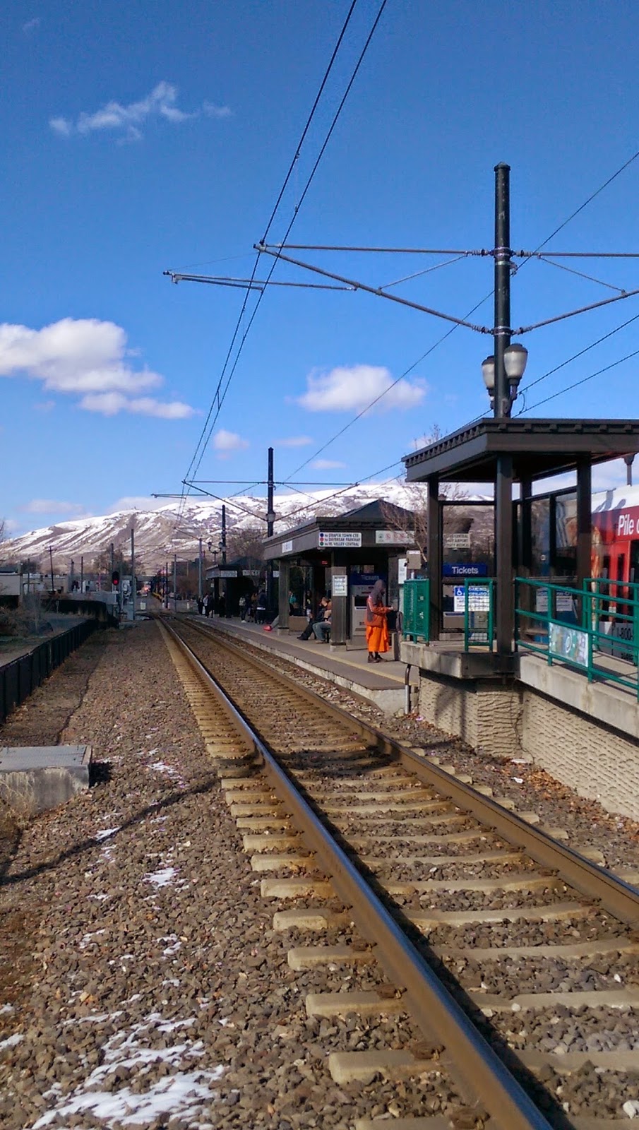
For our assignment today we were asked to take pictures of our assigned community and describe them. Below I have the images I took and the reason why I took them. I am not a professional photographer, but I still think the images of the Ballpark community are quite interesting:
Path Image: is of the TRAX line running past the Ballpark stop. There are a couple cool elements here: I placed the person in orange just right of center as he creates a main focal point. The TRAX line lead to a point just left of center to help balance the person in orange. The image is heavy on the right side, but is balanced because of the mountain in the back creating a line across the mid section of the image helping create a balance of the heavier right side. The contrast between the bright blue sky and the darker brown ground also creates interest.
Edge Image: is of I-15 and the rail line running beneath. 900 South crosses the rail line, and goes under the I-15 bridge. I-15 is an edge of it's own, but the rail line helps to enforce that edge. In addition to the rail line the shadow cast from I-15 also helps define the edge. (I had to wait around a while to get the picture with a train in it so the guard posts would be down as well.) Other interesting things with this photo...in the top right corner you see the bright red sign, that is there on purpose. The shadow line seems to cut the image in 1/2 leading up to that sign. Rail lines have started to make a resurgence, and Union Pacific is one of the biggest, the sign's message makes it a little comical, and again balances the image as most of the weight literally and figuratively is on the left.
District Image: I chose this image to represent the neighborhood district in the Ballpark area. Not only is this image highly typical of suburban neighborhoods, it was highly typical of the neighborhood district of this area. Again you will see the image cut in half with the sidewalk running from the bottom right corner towards the top left. The dark trees fade to the lighter sky and the snow towards the center of the image helps create additional focal points. In usual fashion this image is broken into thirds with the first third being the berm on the left, the center third being the sidewalk and the third section being the grass and houses.
Landmark Image: is of Smith's Ballpark, Home of the Bees. The Smith's Ballpark sign is the center focal point with the large entry way pillars again breaking up the image in very distinct thirds. Your eyes are first drawn to the sign then the pillars, then up toward the sky as the pillars act like giant arrows. The colors draw attention, and although simple the picture has a lot of character.
The next time you walk around your community, see if you can identify it's paths, edges, districts, nodes, and landmarks. Some places might fall into multiple categories, but it will be a fun experiment for you to try.


